Today may have been a long distance but it turned out to be a lot easier than I had anticipated. It was a nice spring day and the majority of the route was flat and fast, a more or less continuous smooth and wide track, initially along the Danube and then on a flood levee through countryside. It was a route suited to making good time and arriving early.
The journey to the river from Bratislava centre was a little dubious; not far from the city centre I found myself definitely on the route but trapped walking between a motorway and a busy dual carriageway which I was meant to cross. However, a big ditch and a five foot fence separated us and even if I had been able to make it to the road, with the morning traffic I did not feel inclined to try and get to the other side.
I backtracked, found an alternative route and was soon on tarmac alongside the Danube, wide, straight and constrained by concrete at this point. I pushed out the distance on the cycle-friendly path and for over twenty miles there was hardly a need to slow down. Unlike cycling to Bratislava my mind and body were as one today despite the fairly repetitive scenery and lack of any major visual distractions. I had to circumnavigate the Gabčíkovo dam, a power project that dates back to the Stalin era and which led to the destruction of the floodplain landscape and associated ecosystem, but then it was back to steady and continuous cycling.
Another thirty-five miles, mostly on a raised levee with no view of the Danube but lovely views across countryside dotted with the yellows, blues, whites and reds of spring flowers, and I arrived at Komárno, the Slovak half of a city that once occupied both sides of the river. However, after European maps were redrawn following the First World War, the Danube became the border between Hungary and the newly created Czechoslovakia. The city on the Hungarian side retained its original name of Komárom while that part now in Czechoslovakia became Komárno. When I first read this sliver of history it brought to mind the videos I saw yesterday in the Bratislava museum and a reminder of the real impact that geopolitics can have on everyday lives.
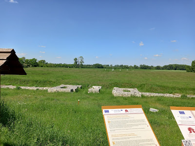
The role of the Danube as a border was highlighted again a few miles later when I stopped at the Roman ruins of Fort Kelemantia. Its remains sit in a wide expanse of grassland alongside the route. Although now there are only a few low-lying walls to show where parts were, it once occupied a large area, looking over the Danube and protecting the edges of the Empire, the river being the border between the Roman Empire to the north and the lands of the Germanic tribes to the south for over three centuries.
I finished the last few miles in a leisurely manner and by mid afternoon had reached the small village of Radvaň nad Dunajom where I had booked accommodation with, as it turns out, a balcony that looks over the river. The opposite shore is Hungary and tomorrow I hope to be in her capital.


No comments:
Post a Comment